A journal to let you all know what we are doing and seeing! Make sure to leave us some comments, just click on the posts...

Friday, February 23, 2007

Doubtful Sound

The Doubtful Sound is much larger than the Milford Sound but it is harder to access. No people live in the area and there are few roads. We had decided to do a two day kayaking trip to the Sound, so we could experience somewhere more remote. There were eight of us including the guide and his friend. It took us a few hours to get to the Sound, crossing Lake Manapouri and then on another road before we got to the Sound. After giving us the opportunity to practise paddling in our seakayaks, with the great help from Ben-our guide, we started our adventure. There are three distinct arms in the Sound. We headed up Halls Arm. Problems can occur on the Sound, due to few places to stop and dramatic weather changes. I think this was probably the safest place for us amateurs to kayak. The water in the Sound is unusual in that it contains two distinct layers of water that do not mix. The top few meters is fresh water, fed from the high inflows from the surrounding mountains. Below this is a layer of cold, heavy, saline water from the sea. Twice a day the tide flows out of the Sound into the Tasman Sea. We kayaked for five hours. It was amazing to be somewhere so remote and quiet. It rained for much of the day, which created a mist across the water-very mysterious. The rain allowed us to see the Doubtful Sound at one of its best-the rainforest looked lush and there were many waterfalls. That night we camped on the Sound in a small inlet beside a stream. Before setting off the next morning we were lucky enough to see one of the most southernmost pods of bottlenosed dolphins. As we set of kayaking, we followed these dolphins, watching them swim gracefully and jump! We kayaked for a few hours and very reluctantly returned back to Deep Cove to begin our journey back to Te Anau( where we were all staying)There is a hydroelectric power station at the Cove, which was built in the Sixties. It discharges water( used to run the turbines ) and research is currently going on to see what damage it may be causing. It was the building of this power station which caused the New Zealanders to become more active in protecting their environment. Despite the power station, once we got further into the Sound, it gave us the opportunity to experience a place that is relatively untouched-a difficult task nowadays.

We had an amazing time-highlight of the trip so far. The group we were with were great and a big thanks to Ben, our guide, who showed us this stunning and magical place. If you want to find out more about the Sounds and some of the research going on with the dolphins, go to www.wikipedia.org and type in the relevant key words. You will now discover where I get most of my facts!


Kayaking on the Sound


Rebecca kayaking


Stephen kayaking-do you like our hats?


One of the many beautiful reflections in the Sound


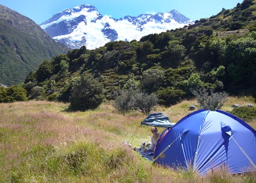
Camp-loads of sandflies so an insect tent was a necessity! I am still itching as I write this...


Wind was up so we got to sail.


View of the Doubtful Sound from the only accessible road.

Milford Sound

The Milford Sound is in the South West of New Zealand, in one of its more remote parts, yet it is one of its most popular tourist destinations. As we knew there would be a lot of people come midday we got up early and drove the two hour Milford Road to get an early morning boat cruise. The Sound is stunning. It is surrounded by sheer granite rock faces which can reach up to 1200m high. Rainforest cling to these cliffs and due to the high rainfall ( it is one of the wettest places in the world,with over 200 days of rain a year) there is no top soil, so often and with no warning there will be a tree avalanche. We were lucky with the weather and had a dry sunny day, which allowed us to see the height of the cliffs around us. In addition to this luck, we saw not only seals and bottle nosed dolphins but also one penguin-the rare yellow eyed fiordland penguin. Milford Sound is named after Milford Haven in Wales, and the Cleddau River which flows into it is similarly named for its Welsh namesake. It is accurately called a fiord(or fjord). A Sound is caused by river flow and fiord is caused by glaciar movement. On discovering it, James Cook thought it was a 'Sound' and although this name has remained, the area it is in is called Fiordland.


One of the most beautiful places so far on our trip...


Falls at the Sound


Reflection of a granite cliff


The Mitre Peak.

Saturday, February 17, 2007

Canyon Swing, Queenstown

Rebecca decided to do the 'Highest Swing in the World.' The Canyon Swing is 110m high with 60m of freefall before swinging into a 200m arc in the valley below. She loved it so much that she did it twice, the second time head first!
The photos do not really do the jump justice as Stephen had to stand on the spectator (wimp) platform. Click on the YouTube link below to see the video


For more info on the swing see: www.canyonswing.co.nz


Rebecca on the edge of the jump platform


All smiles after the jump

Queenstown, New Zealand

We have arrived in Queenstown on the south island. It is in a stunning location next to Lake Wakatipu with mountains all around. You can take part in practically any sport or extreme activity you want, from bungy jumping, skydiving to river surfing and canyoning. On our first full day we took the gondola up to a platform above town and raced around the Luge circuit, which was great fun. We also met up with our friend Leanne who we met on the overland trip in South America. Good to catch up with her and share memories from the trip.


Stephen take a corner on the Luge


Stephen and Rebecca looking down onto Queenstown


View from the beach towards town

Friday, February 16, 2007

Aoraki/Mt. Cook, New Zealand

Mt. Cook is only a short drive from Lake Tekapo. The weather continued to be on our side, with great views of the mountain. We camped nearby and did some great walks while there. Aoraki is the Maori name for Mt. Cook and means 'Cloud Piercer.'


The sun sets on Mt. Cook - the view from the Old Mountaineers' Cafe


Rebecca preparing our camp - what a view!


Mt. Cook and surrounding area


Rebecca, Stephen and Mt. Cook

Lake Tekapo, New Zealand

With Christchurch and some very dodgy weather behind us we travelled south to Lake Tekapo. Uncertain of the meters of rainfall we might encounter, we were greeted with clear blue skies and the most beautiful lake I have ever seen. A couple of days were spent exploring some of the many walks in the hills around the lake.


The sun setting on the red earth hills surrounding the lake


Rebecca walking the trail up to the Mt. John summit


Stephen at the summit


Church of the Good Shepherd, on the shore of Lake Tekapo


How blue is that Lake!

Christchurch, New Zealand

Christchurch was our next stop as we postponed our dolphin swimming trip in Kaikoura due to bad weather. The city is very pretty and reminded us a lot of Cambridge back home. Lots of gardens, punting and tourists like us!

Marlborough Sounds

Our first night camping on the South Island (now with Dave's slightly larger tent, thank goodness - sorry Naomi!) was at Momorangi Bay in the Marlborough Sounds. It was a beautiful setting and the next day we walked a section of the Queen Charlotte Track.

Crossing the Cook Strait

We took the Interislander ferry for a wonderfully scenic crossing of the Cook Strait from North to South Islands. The last section passes through the Marlborough Sounds (see picture)

More from Wellington...

Back in Wellington, we spent a couple of days exploring the excellent Te Papa Museum. On our final night we went snorkeling, swimming and kayaking again in Island Bay. We had a great week with Tash and Dave, who were excellent hosts.


Tash shows us her skills in the kayak


People cool off by diving into the harbour in the city

The Puntangirua Pinnacles

After the wine tasting we drove further across the Wairarapa to the Puntangirua Pinnacles. For any "Lord of the Rings" fans out there, it features as a location in the film. They were formed by rain washing silt and sand away, revealing the underlying bedrock. Amazing landscape, have never seen anything else like it.


Wednesday, February 07, 2007

Wine Tasting in Martinborough

East of Wellington is the wine producing region of Martinborough, set in beautiful countryside. Our finely tuned taste buds were once again put to the test - what a chore.


So cultured!


Definately "sweaty socks"


Hard work

An evening in Island Bay

After a great BBQ at Dave and Tash's we took a walk down and along the coast at sunset. On a clear day from the beach at the end of their road you can see the South Island across the Cook Strait.


The view of Island Bay from Dave and Tash's house


Looking over the Cook Strait at sunset

Snorkeling Lesson

With the beach being at the end of his road, Dave offered to give us a snorkeling lesson. After squeezing into our wetsuits, we explored the shallow waters of Island Bay, their neighbourhood. The water was extremely cold though and I think we scared most fish away with the flapping of flippers on our first attempt! Who do you think looks best in a wetsuit? (I'd say the fella in the middle...)


Wellington, New Zealand

We travelled to stay with our friends Dave and Tash who live in the capital Wellington, in the south of the North Island. The city has a great location, surrounded by hills and clear blue waters. The architecture of the houses is very pretty, with lots of wood and colourful paint being used.